|
GEOMAGIA50 - Home
|
Welcome to the GEOMAGIA50.v3 database
|
|
NEWS: 01.22.2021
|
Update to version 3.4 of GEOMAGIA50:
In addition to the over 500 new entries from 28 publications primarily from 2019 and 2020 that were added to the database in September 2020, 755 additional entries were added in January 2021. This includes 698 revised and new directional data from France (Le Goff et al., 2020).
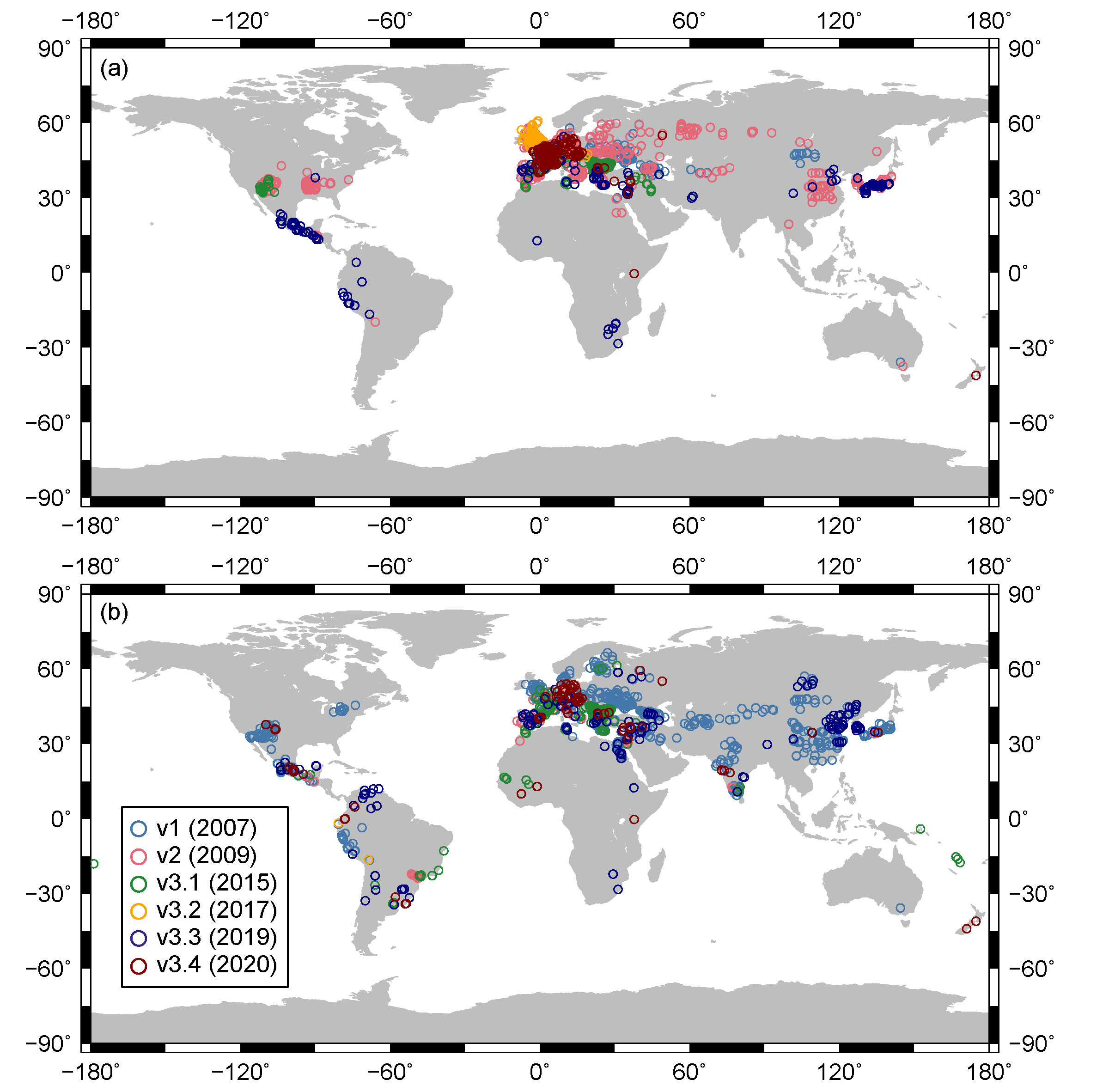
Map of all archaeomagnetic and volcanic locations in GEOMAGIA50. (a) directions; (b) intensity. Data added in different versions of the database are coloured and given in the legend.
All revisions made by Maxwell Brown (University of Minnesota) and Gwenaël Hervé (Laboratoire des Sciences du Climat et de l'Environnement, Université Paris-Saclay).
Please cite the latest version of the database as GEOMAGIA50.v3.4 and add the date the data were downloaded. The relevant publication to cite remains:
Brown, M.C., F. Donadini, M. Korte, A. Nilsson, K. Korhonen, A. Lodge, S.N. Lengyel and C.G. Constable, GEOMAGIA50.v3: 1. General structure and modifications to the archeological and volcanic database , Earth Planets Space 67:83, doi:10.1186/s40623-015-0232-0.
Please note that there are still likely errors within the database. If you find errors please contact Maxwell Brown (mcbrown@umn.edu). Through a community effort this will greatly improve the quality of the database.
|
|
About GEOMAGIA50
|
GEOMAGIA50 is an international collaboration to provide easy access to published archeomagnetic/volcanic and sediment paleomagnetic
and chronological data for the past 50 ka. It has been funded by the National Science Foundation (NSF
and the German Research Foundation (DFG) SPP 1488 and
is or has been supported by the following institutions:
GFZ Potsdam, University of California San Diego, University of Freiburg, University
of Liverpool and the University of Helsinki.
This web interface allows users to search the database by data type using chronological and geographical constraints.
|
|
Updates and Error Checking
|
Please check the log webpage for corrections and updates to the database.
Current update: 22nd January 2021.
Previous update: 25th August 2020.
If you spot any errors in the database please contact Maxwell Brown (University of Minnesota).
We appreciate any user feedback on the database.
|
|
Citations
|
If you use this database please cite it.
Two papers describing the functionality of GEOMAGIA50.v3 have now been published in Earth Planets Space.
For queries made from 2015 onwards using the archeo/volcanic database please cite:
-
Brown, M.C., F. Donadini, M. Korte, A. Nilsson, K. Korhonen, A. Lodge, S.N. Lengyel and C.G. Constable,
GEOMAGIA50.v3:
1. General structure and modifications to the archeological and volcanic database
, Earth Planets Space 67:83, doi:10.1186/s40623-015-0232-0.
For the sediment database please cite:
-
Brown, M.C., F. Donadini, A. Nilsson, S. Panovska, U. Frank, K. Korhonen, M. Schuberth, M. Korte
and C.G. Constable, GEOMAGIA50.v3 : 2.
A new paleomagnetic database for lake and marine sediments ,
Earth Planets Space 67:70, doi:10.1186/s40623-015-0233-z.
For queries made prior to 2015 please cite:
-
Donadini, F., K. Korhonen, P. Riisager, and L. Pesonen (2006),
Database for Holocene geomagnetic intensity
information, EOS, Transactions, American Geophysical Union, 87(14), 137.
-
Korhonen, K., F. Donadini, P. Riisager, and L. Pesonen (2008),
GEOMAGIA50: an archeointensity database with PHP and
MySQL, Geochemistry, Geophysics, Geosystems, 9, doi:10.1029/2007GC001,893.
|
|
Archeomagnetic and Volcanic Database
|
At present, the archeomagetic and volcanic database contains over 9000 entries of geomagnetic
field directions and intensities.
The GEOMAGIA50 archeomagnetic/volcanic
interface allows:
-
selecting and downloading archeomagnetic/volcanic data using various constraints.
-
calculating ARCH3k.1, CALS3k.4, CALS10k.1b, SED3k.1 and pfm9k.1a geomagnetic field model outputs
for any location with the option to download the model
output as text files. Descriptions of the models can be found here.
-
plotting data and models in time.
-
visualizing data using Google Earth.
|
|
Sediment Database
|
The sediment database currently contains approximately 45,000 individual (specimen/stratigraphic) level data entries from 52 locations,
5000 processed (averaged/smoothed) data entries from 19 locations, 450 radiocarbon ages from 38 locations and 640 general age data from 8 locations.
More data will be added with time, so please revisit the database.
The GEOMAGIA50 sediment interface allows:
-
selecting, downloading and online viewing of sediment data using temporal and geographic constraints.
-
calculating and downloading SED3k.1, ARCH3k.1, CALS3k.4, CALS10k.1b and pfm9k.1a geomagnetic field
model outputs based on the above constraints. Descriptions of the models can be found
here.
If you have comments or suggestions feel free to contact Maxwell Brown (University of Minnesota).
|